

Files
Download Full Text (6.9 MB)
Identifier
FLSC_TJPC_01272017_0309
Description
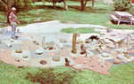
This color photographic postcard features an attraction on Ray Smith Ranch in Ottawa County, Kansas. It depicts a concrete map of the United States and a portion of Canada. Rocks are embedded in the area where the rocks are prevalent. For example, there is limestone in the Kansas area of the map. There is a cat sitting at the bottom of the display. A man in a ballcap, plaid shirt and jeans is standing on the left side of the attraction. Grass and trees surround the concrete. A picnic table is in the background. Printed text is on the back of the card.
Physical Description
4"x 5" photographic postcard
Subject
Ottawa County (Kan.), Rock gardens, Parks, Attractions, Petrology, Installations (Art)
Rights
This material may be protected by copyright law (Title 17 U.S.Code)
Publisher
Digitized by FHSU Digital Collections
Collection
Repository
Recommended Citation
"Postcard: Rocks on a Concrete Map of the U.S." (2021). Tim Johnson Postcard Collection. 210.
https://scholars.fhsu.edu/tj_postcards/210
Language
eng
Transcription
This concrete map of the U.S. and Canada w/ native rock embedded in their home state or province seen on the Ray Smith ranch, 7 mi. SW of Longford in eastern Ottawa Co., Kansas. Photo by Kirn Photos, Mpls., Kansas.


Comments
For questions or to request permissions, contact [email protected]