

Preview
Identifier
sa2-072-01
Date
1916
Description
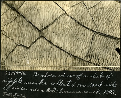
This black and white photograph features a close-up view of the ripple marks found on the east side of the river. The ripple marks are split by numerous cracks in the rock itself. The cracks themselves are called mud cracks, meaning that the sediment has contracted and split over time. These ripple marks, upon close inspection, appear to have been created by the water moving from the northeast to the southwest per the angle of the picture. On the bottom right side the handle of a brush can be seen as well as a small tape measure. On the left-hand side a small white ink splotch from Sternberg's pen can be found. Handwriting is below the photograph.
Physical Description
black and white photograph
Keywords
Paleontology, Expedition photographs, Rock formations, Erosion, Watermarks, Canada, Measurement
Rights
© University Archives, Fort Hays State University
Publisher
Digitized by FHSU Digital Collections
Collection
Recommended Citation
Sternberg, George Fryer 1883-1969, "072-01: Ripple Marks on the Quarry" (1916). George Sternberg Album #2 - Early Canadian Views. 271.
https://scholars.fhsu.edu/sternberg_album2/271
Language
eng
Transcription
35140-16. A close view of a slab of ripple marks collected on left side of river near R. Tolman's ranch, R-22, T-33, S-26
Keywords
Paleontology, Expedition photographs, Rock formations, Erosion, Watermarks, Canada, Measurement

Comments
For questions contact ScholarsRepository@fhsu.edu