

Preview
Identifier
8x10_006_1986_44_4338
Approximate Date
July 1941
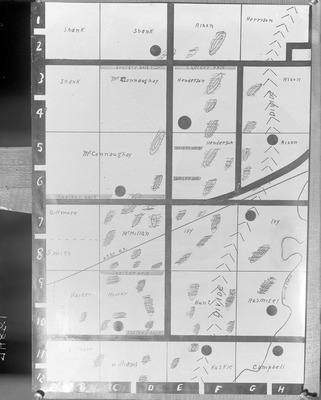
Description
This black and white photograph features an illustration and description of a hand drawn map that shows landowners' names, roads and the route of the A.T.S.F. railroad. Colen Hoover ordered the photograph.
Physical Description
8" x 10" Glass-plate negative
Subject
Drawings, Stafford County (Kan.)
Rights
© Stafford County Historical and Genealogical Society. All rights reserved. May not be reproduced without permission. Please credit Stafford County Historical and Genealogical Society as your source.
Publisher
Access provided by FHSU Digital Collections
Collection
Gray Studio Glass Plate Negative Collection
Recommended Citation
Gray, William R., "Box 6, Neg. No. 74881: Photograph of Map - Landowners and Railroads" (1941). Stafford County Museum Collection. 6682.
https://scholars.fhsu.edu/stafford_county/6682
Language
eng
Keywords
Drawings, Stafford County (Kan.)

Comments
For questions contact the Stafford County Historical and Genealogical Society.